
Hounslow has made an order adding the locked riverside path around Brentford Dock to the definitive map. Objections close 31 October; an inquiry is likely.
Hounslow Council has decided that the walk around the edge of the Brentford Dock estate is reasonably alleged to be a public footpath, and has made a legal order to add it to the borough’s definitive map of rights of way.
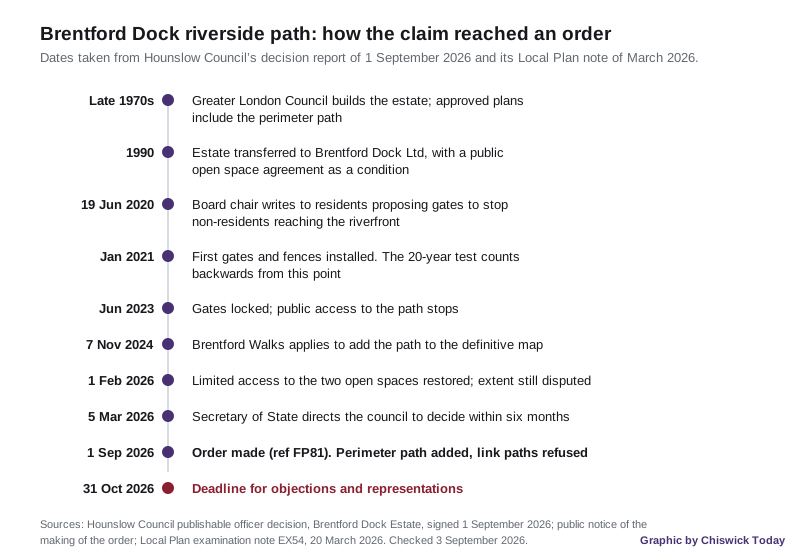
The order was made on 1 September 2026. Anyone who wants to object has until 31 October.
The path runs around the perimeter of a private residential estate of around 600 homes, on the peninsula between the River Brent and the Thames. Brentford Dock is about two and a half miles west of Chiswick. Public access to the riverside route was blocked in June 2023, when the estate’s owner locked a set of gates it had installed over the previous two years.
What the order actually does
The order is called the London Borough of Hounslow (Addition of a Public Footpath at Brentford Dock Estate) Modification Order 2026, and it carries the reference FP81. It was made under section 53(2)(b) of the Wildlife and Countryside Act 1981.
If it is confirmed, the council’s public notice says it will add a public footpath “comprising the route around the perimeter of the Brentford Dock Estate, following the waterfront edge of the area bounded by the River Thames and associated waterways”.
The word “if” is doing a lot of work. Making an order is not the same as confirming one. The council’s decision report sets out what happens next:
- objections and representations must be in writing, quoting reference FP81, by 31 October 2026
- if nobody objects, the council can confirm the order itself
- if anyone objects, the order goes to the Secretary of State
- that is likely to mean a public inquiry before a Planning Inspectorate inspector, with evidence given on oath
Given that the landowner formally argued against the application in February, objections look probable. The report says so in as many words, and warns that the legal costs will have to come out of existing budgets because the council has no specific budget for public rights of way.
Objections go to the Head of Transport Planning and Road Safety at Hounslow House, 7 Bath Road, Hounslow TW3 3EB, or by email to traffic@hounslow.gov.uk.
Who applied, and on what evidence
The application came from Brentford Walks, now a community interest company, and reached the council on 7 November 2024. It was duly made, with the required certificate of service, on 16 December 2024.
The claimed route was drawn in two colours. The green route is the circular perimeter path. The blue routes are shorter links from that path into the estate, towards Augustus Close and Justin Close.
The council approved the green route and refused the blue ones. Officers found no real evidence in the witness statements that the public had used the link paths, as opposed to the perimeter walk.
The evidence behind the green route was more than 48 signed witness forms describing use between 1978 and June 2023, plus two longer statements from an estate resident and a local historian. The report breaks it down:
- the longest single claim of use was 44 years, from 1979 to 2023
- 21 witnesses claimed at least 20 years of use
- a further 16 claimed between 10 and 18 years
- 21 walked the route at least weekly, four of them at least daily
- 16 used it at least monthly, and 22 fewer than 12 times a year
Twenty years matters because of section 31 of the Highways Act 1980. If the public has used a way “as of right” and without interruption for 20 years, it is presumed to have been dedicated as a highway unless the owner can show it never intended that. The clock counts backwards from the moment the right is brought into question, which the council put at January 2021, when the first gates went up.
How the estate came to be private
The estate was built by the Greater London Council on the site of a railway goods yard, starting in about 1972 and largely finished by the end of the 1970s. Permission for the revised scheme was granted on 26 April 1978. The approved 1970s plans included the perimeter path and areas of open space.
The GLC’s successor, Hounslow Council, transferred the estate to its current corporate owner in 1990. As a condition of that transfer, the council and the landowner signed a Public Open Space Agreement covering two areas of open space inside the estate.
Brentford Dock Ltd is both the freeholder and the estate management company. The homes are held on separate long leases.
The gates
The report traces how access closed, and it does so mostly from the landowner’s own paperwork.
On 19 June 2020 the company’s board chair wrote to residents. The letter, quoted in the report, says the estate had “become an attraction for large numbers of non-residents, walking their dogs, cycling, running and picnicking” during lockdown, that extra signage had “proven to be an ineffective deterrent”, and that the board’s “main objective and proposed first step (others may follow in the future) is to prevent non-residents accessing the riverfront”, using gates and railings with key fobs or push-button locks.
What followed, on the applicant’s evidence as summarised by the council:
- January 2021: gates and fences at the end of the public footbridge over the River Brent and at Dock Road, plus a wooden picket fence across part of the path
- 2021 to 2023: gates installed at access points, but left unlocked at least in part, so the walk stayed usable
- June 2023: all the gates locked, ending public access
- 2025: further gates installed
In late 2022 and early 2023, after complaints, the council tried to impose an Article 4 Direction as local planning authority. That would have stripped the landowner of the permitted development rights it used to put up more gates. The attempt failed after a legal challenge from the landowner. Officers treat that episode as telling: it suggests there had not previously been many gates, let alone locked ones, along the route.
What the landowner says
The landowner’s solicitors responded formally on 27 February 2026, and their conclusion is quoted in full in the report. Their case is that there has been no period since the estate was first occupied in 1978 to 1979 without “clear evidence of a lack of intention by the landowner and its management to dedicate any public rights of way”, and that anyone using the paths did so by permission rather than as of right.
They point to “copious signage, barriers and verbal challenges” from the start, and say security guards have challenged non-residents since the early 1990s.
Officers went through that evidence sign by sign and were not persuaded. Their reasons, in the report:
- most of the signs are not on the claimed route, or face away from it, or are ambiguous about whether they refer to the path or the surrounding landscaping
- only two signs anywhere on the estate say there is no intention to dedicate land as public highway, and neither is visible from the claimed route; both refer to roads rather than footpaths
- several “private estate” signs are simply wrong, because they sit on stretches of Augustus Close and Justin Close that are adopted public highway
- the landowner has never served the council with a notice under section 31(5) of the Highways Act, the formal route for putting a lack of intention beyond argument
- the “chain” said to have blocked the Syon Park side of the path could not be evidenced from photographs, maintenance records or any witness
One detail from the landowner’s own side stuck. A resident who has lived on the estate since the early 1980s said in a witness statement that they “first became conscious of the private nature of the estate” in 1998.
The open spaces are a separate argument
Running alongside all this is a second dispute the order does not settle. The two public open spaces inside the estate are protected by the 1990 agreement, not by the definitive map. In a note to the Local Plan inspectors in March 2026, the council said access to those spaces had been “restricted and / or totally prevented” by the management company, and that access had been reinstated from 1 February 2026 “albeit to a limited extent”, with the route and the opening times still in dispute between the two sides’ lawyers.
That is a contract argument about property rights. The footpath order is a separate question about whether a public right of way exists. The council was explicit that the two are distinct.
What it means for you
Nothing about the order opens a gate today. The path is added to the map only if the order is confirmed, and on the council’s own reading that is unlikely to be settled before 2027 or 2028.
What you can do now, before 31 October 2026:
- if you have walked the perimeter path and want the order confirmed, or you object to it, write to the Head of Transport Planning and Road Safety at Hounslow House, 7 Bath Road, Hounslow TW3 3EB, or email traffic@hounslow.gov.uk, quoting FP81
- state the grounds. Bare support or bare opposition carries little weight at an inquiry; first-hand evidence of when and how often you used the route is what the process runs on
- the order and the order map can be downloaded from the council’s public rights of way page, or inspected free at the council’s offices, Monday to Friday, 9.30am to 4.30pm
One further wrinkle. Because the blue link paths were refused, Brentford Walks can appeal that refusal to the Secretary of State within 28 days of being notified. The report notes the blue routes could also come back into play at any rehearing if the order is opposed.
The decision was signed by Peter O’Brien, executive director for placemaking and growth, under officers’ delegated powers. The wards affected are Syon and Brentford Lock.
For other decisions being taken locally, see our Chiswick planning news page.
Have your say